
Events
National Surveyors Conference
Porter (www.flyporter.com)
Porter Airlines is proud to offer a up to 10% discount on available base fares (with the exception of the lowest class fare during a public seat sale) for travel to and from National Surveyors Conference 2025 . The discounted fares are available for booking from August 08, 2024 to May 05, 2024 and available for travel:
From: All Markets To: Victoria (YYJ) From: 04May25 To: 08May25 From: Victoria (YYJ) To: All Markets From: 07May25 To: 11May25
Please book online at https://www.flyporter.com/en-ca/?promocode=NSC025 or through your travel agent using the promo code
“NSC025”
Porter offers complimentary in-flight snacks and beverages (including beer and wine), GatePorter service for carry-on and access to the Porter Lounge in Toronto where free Wi-Fi and comfortable, leather seating is available.
The promo code is intended for use by conference attendees and organizers and is not meant for distribution outside of authorized channels. Porter’s fare rules and conditions apply. For any questions regarding Porter’s services or any pre-travel concerns, contact us at 1-888-619-8622. Harbour Air (https://harbourair.com/)
LanguageMost conference presentations will be in English. Interpretation will be done via the Zoom meeting platform for online and in person attendees.
InsuranceThe secretariat and the organizers of NSC 2025 cannot be held responsible for personal accidents, loss, or damage to personal property of conference participants or of persons accompanying them, whether during the conference or during events or activities. It is the sole responsibility of the participants to obtain travel, health, and personal property insurance.
Clothing & WeatherThe dress code for the conference is informal for all occasions. The average temperatures in Victoria during the month of May are generally 16 °C (day) and 10 °C (night). |


See all events
from Tuesday 6 May
06:00
to Friday 9 May 2025
21:00
(GMT -7)
Registration deadline : 25th April
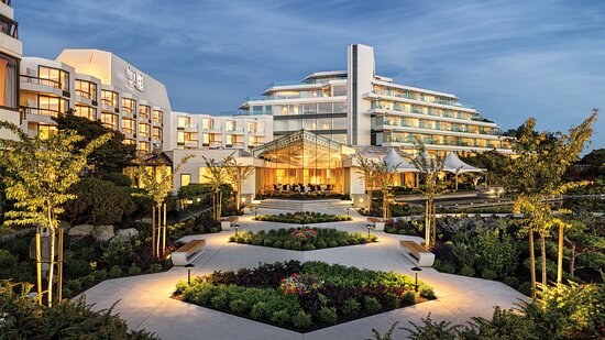
Inn at Laurel Point
680 Montreal Street
V8V 1Z8
Victoria
Canada
-
$680.00 (+ tax) Member Rate (includes Icebreaker, Gala, lunches and all sessions)
-
$640.00 (+ tax) Retired Member & Student Rate (includes Icebreaker, Gala, lunches and all sessions)
-
$800.00 (+ tax) Non-Member Rate (includes Icebreaker, Gala, lunches and all sessions)
-
$520.00 (+ tax) ONLINE - streamed via zoom
-
Free Guest linked to your registration (Conference sessions NOT included for guests)
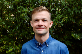
Jesse Robertson is a historical consultant and practitioner based in Victoria, BC (lək̓ʷəŋən territory). His recently completed doctoral research examines histories of marine navigation and colonialism in the Pacific Northwest. His dissertation considers the exchange of navigational knowledge and practices between Indigenous and imperial mariners, showing how voyages of reconnaissance, hydrographic charts, and lighthouses transformed the coast by permitting newcomers to transit its waves without local consent or assistance.
Jesse has over a decade of experience as a historical consultant, having conducted property reports, oral histories, Traditional Knowledge and Land Use Studies, and archival research for government, faith groups, legal teams, and Indigenous clients. He has written reports for Parks Canada and the Historic Sites and Monuments Board of Canada and has authored a historical entry in the Canadian Encyclopedia. When he’s not in the archives, Jesse can be found playing guitar from his porch or hiking the coastal landscapes he loves to research and write about.
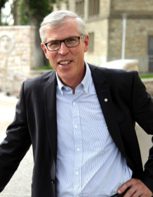
Bill Waiser is one of Canada’s foremost historians. For more than three decades, he was a history professor at the University of Saskatchewan. He is now a full-time writer and public speaker.
Bill has published 21 books, in addition to plying his trade in radio, television, and print media. He’s known for his engaging, popular style that draws on the power of stories. Both the Mosquito Nakoda First Nation and the Saddle Lake Cree Nation have honoured Bill with a blanketing ceremony for his work on Indigenous/non-Indigenous history.
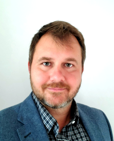
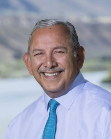
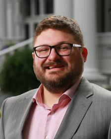
Dr. Robert Radovanovic, P.Eng., P.Surv., CAMA, Env SP, is the Director of IPSAR Inc. With 25 years of experience in land surveying, infrastructure engineering, and software development, he has worked in startups, executive management, and board governance. Now, he focuses on industrial education and strategic consulting through Digital Skillet, leveraging AI to enhance company processes, while also serving as an Adjunct Professor at the University of Calgary.
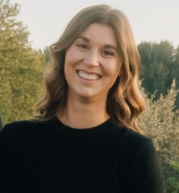
Noelle Machon is a land surveyor at Natural Resources Canada’s Surveyor General Branch in Edmonton. She earned her Geomatics Engineering degree from the University of Calgary and became a commissioned Alberta Land Surveyor in 2019 and a Canada Lands Surveyor in 2020. Since joining the Surveyor General Branch, she has worked with First Nation communities across multiple provinces, conducting field surveys, historical research, and addressing survey-related concerns.

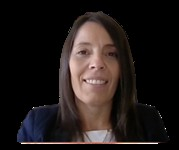
Angie Derrickson is a proud member and elected Councillor of Westbank First Nation (WFN) in the Syilx Okanagan territory of British Columbia. She has extensive expertise in First Nations land governance, land management, and self-governance initiatives.
In June 2024, she was appointed as the inaugural Registrar of the First Nations Land Governance Registry (FNLGR). Previously, she served 11 years as Training, Mentorship & Professional Development Manager at the First Nations Land Management Resource Centre and 17 years with WFN, including 11 years as Senior Lands Officer.
In December 2022, she was appointed by the Minister to the ACLS Council, contributing to survey regulations and standards in Canada. That same year, she was elected to WFN Council, advancing strategic priorities related to WFN’s land base, cultural values and governance.
She holds certifications from University of Saskatchewan, Justice Institute of BC, and Royal Roads University.
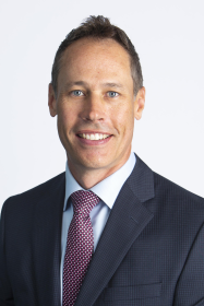
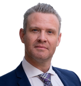
Rod Zelli, P.Eng., C.L.S., is a Senior Surveyor at Natural Resources Canada with over 26 years of experience in cadastral surveys on Canada Lands and Indigenous engagement. He specializes in researching historical field notes for reserve land descriptions and leads knowledge-sharing programs that integrate Indigenous knowledge with modern surveying practices. Outside of work, he enjoys coaching his son in ice hockey and spending time outdoors in British Columbia.
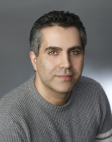
Mr. Sampson has been in the insurance industry for 26 years and is the Senior Vice President for Arthur J. Gallagher Canada Limited. He is the professional liability insurance broker representing the members of PSC.
Gallagher operates in every province and are widely regarded in the insurance industry as one of the leading brokerages for professional liability insurance. They specialize in developing professional association group errors and omissions liability programs.
Paula Barreira, B. Soc. Sc., CIP, CRM
Paula Barreira joined Victor in 2004 as an underwriter for the Architects and Engineers department (A&E) and then joined the A&E Claims department in 2008 where she is currently a Claims Specialist. She is a graduate from the University of Ottawa with a Bachelor of Social Sciences degree (concentration in Criminology). Paula received her Chartered Insurance Professional (CIP) designation in 2007 and her Canadian Risk Manager (CRM) designation in 2008.
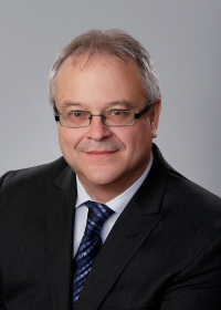
Jean Gagnon has been the Surveyor General and Director General of the Surveyor General Branch since 2017, recently retired, and has been with the branch since 1992, holding various leadership roles. He is Canada’s Commissioner on the International Boundary Commission and a statutory member of several surveying organizations. With a background in engineering and land surveying, he has experience in both the public and private sectors, including co-founding East Coast Surveys Ltd.
Roy Pogorzelski is a Métis/Cree professional from Saskatchewan with extensive experience in inclusion, reconciliation, and Indigenous affairs. He has worked in government, academia, and consulting, including roles with the City of Lethbridge, the University of Lethbridge, and various national advisory committees. Currently, he is an Associate with the Canadian Centre for Diversity and Inclusion, an Indigenous Specialist with Harbour West Consulting, and a PhD candidate at the University of Lethbridge.
Chris Farrelly, P.Surv, CH Cat A, PTech, CMarSci (hydrography) is a highly experienced hydrographic and geomatics surveyor with over 18 years in government and private industry, specializing in construction, engineering, exploration, and navigation safety. He holds advanced degrees in Geomatics and Hydrography and has worked internationally, including in Canada's legal survey framework and the Gulf of Mexico’s oil and gas sector. As the founder of Trident Hydrographic Services, he provides expert surveys and consultancy, holding prestigious certifications, including Level 1 Category A Hydrographic Surveyor and Chartered Marine Scientist in Hydrography.
Tuesday 6 May
Kick off the National Surveyors Conference with our dynamic Icebreaker Event featuring leading exhibitors!
Connect & Collaborate: Meet industry experts, innovators, and fellow surveying professionals in a relaxed, engaging setting.
Experience Innovation: Explore interactive exhibitor booths showcasing the latest in surveying technology, tools, and services.
Ignite New Opportunities: Build relationships that can propel your career and business forward with hands-on demos and live discussions.
Join us to spark fresh ideas, forge lasting connections, and set the tone for a groundbreaking conference experience. Appetizers and refreshments provided.
Wednesday 7 May

You won’t find the Ocean Man and Pheasant Rump reserves on a map of southeastern Saskatchewan. In 1901, the two Nakoda bands reluctantly surrendered the 70 square miles granted to them under treaty. It’s just one of more than two dozen surrenders aggressively pursued by the Laurier Liberal government over a 15-year period. One in five acres was taken from First Nations.
This confiscation was justified on the grounds that prairie bands had too much land and that it would be better used by white settlers. In reality, the surrendered land was largely scooped up by Liberal speculators — including three senior civil servants and a Liberal cabinet minister — and flipped for a tidy profit. None were held to account.
Cheated is a gripping story of single-minded politicians, uncompromising Indian Affairs officials, grasping government appointees, and well-connected Liberal speculators, set against a backdrop of politics, power, patronage, and profit. The Laurier government’s settlement of western Canada can never be looked at the same way again.


-60 ft catamaran, indoor and outdoor seating, glass cabin for easy indoor viewing, 2 washrooms, wheelchair access
Whale Guarantee!
Incredible wildlife viewing
Onboard wildlife identification kits
Gloves, jackets, hats, sunglasses, sunscreen, blankets
Knowledgeable onboard naturalists/biologists
Onboard washrooms on all boats!
Hydrophone—you can actually hear the whales!
Luxury vessels
What to bring
Cameras (and their protective cases)
Warm clothing, in layers (it’s cool out there!)
Woolly hats, gloves
Water in a reusable container
A smile and a sense of adventure!
Please refer to “Our Safety Pledge” for more details.
Thursday 8 May
Presented by: Rod Zelli, P.Eng., C.L.S., is a Senior Surveyor at Natural Resources Canada, Surveyor General Branch, BC Regional Office, with over 26 years of experience in land surveying. An expert in cadastral surveys on Canada Lands, Indigenous engagement, and land surveying activities under the Framework Agreement on First Nation Land Management, Rod has gained extensive experience in researching historical field notes to prepare land descriptions for reserve lands subject to the First Nations Land Management Land Code. Passionate about empowering First Nations communities, Rod has led knowledge-sharing program in BC that align Indigenous knowledge with modern surveying practices. Holding professional designations as a Canada Lands Surveyor and Professional Engineer, Rod blends technical expertise with strategic planning to support sustainable land use. Outside of work, he enjoys coaching his son in ice hockey and outdoor activities in beautiful BC


Table Topics
Modern field notes - why we need them and what they include?
truth and reconciliation - what should be in a land acknowledgement
Air photo interpretation for water boundaries (drone)
GIS – remote sensing
Common jurisdiction boundary - Canada Lands and other lands, how to resolve conflicting information?
Building units on reserve lands
Data retention - advanced tools what do you keep?
Offshore topic- TBD
What NOT to include in your survey reports? Privacy considerations
surveying under a land code
Metes and bounds discrepancies
project management software
Using the different registries

Through a storytelling approach, this session will discuss the importance of understanding meaningful engagement with Indigenous communities. How to work collaboratively in proper consultation on projects. A deeper look into what is meant by Indigenous knowledge, how it differs from Western Knowledge and how we can incorporate both knowledge bases into the work that we do. The session will also include how we can take practical steps to create transformational change when we talk about implementing Truth and Reconciliation into our work.
- Roy will discuss his lived experience as a Metis/Cree person
- This session will discuss what meaningful engagement looks like with Indigenous communities
- This session will discuss Incorporating Indigenous Knowledge with Western approaches to Knowledge production
- Practical steps we can take to be a leader in working with and engaging Indigenous communities

This session will highlight the role and significance of Category A hydrographic surveyors, the skills and qualifications required, and the ACLS certification pathway. Discover upcoming mandates to require ACLS certified hydrographers. Learn from real-world examples as Chris Farrelly shares experiences from key projects both at home and away.
Don't miss this opportunity to understand why using ACLS certified hydrographic surveyors is essential for your projects and how it ensures higher standards and accuracy in hydrographic surveys.

Step into an evening of prestige at the National Surveyors Conference President's Gala—a night where innovation, legacy, and leadership converge. Join us as we honor the exceptional achievements within our community with distinguished awards and exclusive commissions.
Awards & Accolades: Recognize and celebrate industry trailblazers whose contributions shape the future of surveying.
CLS Commissions: Witness the presentation of new commissions.
Elegant Networking: Mingle with peers, thought leaders, and decision-makers in an atmosphere of celebration and inspiration.
A Night to Remember: Enjoy a sophisticated setting paired with gourmet dining, live entertainment, and unforgettable moments.
Be part of this prestigious event—where your achievements are celebrated and the future of surveying is forged. Reserve your seat at the President's Gala today!
Attire - Dressy Casual or Casual Chic
Friday 9 May
Bus transportation to and from venues. Wine tasting at Church and State Winery with charcuterie, Cider tasting at Sea Cidery with appetizers, Brewery and tasting and Whistle Buoy Brewery.
Sponsored by Challenger Geomatics & McElhanney
Inn at Laurel Point
680 Montreal StreetV8V 1Z8 Victoria
Canada
Additional information (parking, underground, etc.)
Covered, paid or valet available onsite